
If all of its engines fail, it will land somewhere in the middle of the Atlantic. There are many possibilities.
Now, if it’s a twin-engined aircraft, and ONE of its engines fail, it will proceed to the nearest ETOPS (ICAO: Extended Twin Operations) Alternate Airport associated with the closest ETP (Equal Time Point). If it’s lucky enough to have more than two engines, and loses power on one engine, it may continue to its destination, fuel depending.
Assuming it’s a twin, and one engine fails over the North Atlantic. It will be subject to ICAO ETOPS requirements. ETOPS 180 (minutes) is typically used for flight planning.
It will likely be flying one of the random North Atlantic Tracks (NATS) routes that are generated daily, the routing dependent upon on prevailing winds aloft, turbulence, and weather systems. Prior to departure, the aircraft’s own airline will generate a flight plan, which will be based on an expected NATS track over the Atlantic. The tracks have letters, such as Track A, B, C, etc. They generally parallel each other, and are located 10 degrees of latitude apart, but may be reduced to 5 degrees of latitude separation for heavy traffic volume. The Navigational points along a given track will be spaced 10 degrees of longitude apart.
For example, NATS Track F (Foxtrot) will be defined as (Easterly Direction): TUDEP N52W050 N53W040 N53W030 N52W020 DINIM. The controlling agencies on the NATS will generally be GANDER OCA until 030W, then SHANWICK OCA.
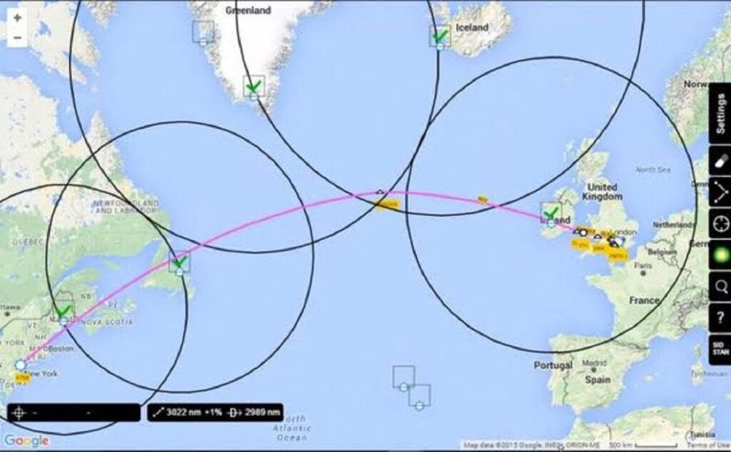
The flight plan will generally include 3 alternate airports, so that the aircraft is never more than 180 minutes of flying time from at least one of those airports. The chosen airports must meet the reduced weather forecast criteria for an aircraft flying an engine out approach. There will usually be two points generated along the assigned NATS routing called ETP’s, which are the points at which you will be within 180 minutes of the airfield associated with that geographical position.
For a flight from New York’s JFK to London’s Heathrow Airports, we will typically use Gander (CYQX) or St. John’s (CYYT) Airports for the first ETOPS airfield, Keflavik (BIKF) or Lajes (LPLA) for the middle portion of the flight, and Shannon (EINN) for the final portion. These can change for weather, winds, or geographical location of the NATS.
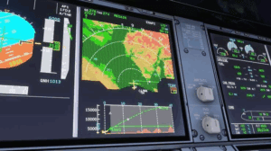
This is a North Atlantic transoceanic plotting chart with the relevant ETOPS information plotted on it. Once it has been flight-prepped, it is known as an “Oceanic Orientation Chart”. Paper versions are becoming extinct, replaced with electronic versions, usually a Jeppesen Chart displayed on an electronic tablet, or on the aircraft’s own Moving Map Horizontal Situation Display.
- An aircraft traveling East, or left to right, would divert to CYYT (St. Johns) prior to the first vertical line (located at the first ETP (equal time point)).
- *Note the triangle drawn at the top and bottom of the vertical ETP line. It points towards the divert airport, and has the appropriate divert airport ICAO code written next to it.
- After the first line, the aircraft would divert to Lajes (LPLA). At the second vertical line drawn on the planned route line, the aircraft would divert to Shannon (EINN).
- At each ETP line, the aircraft will be equal flying time between the two airports associated with the ETP.
Author – Steve Bazer (Former Airbus A350 Captain at Delta Air Lines)